Tilton Conservation Commission
                Tilton, NH

                                                                                                                                                                                                     
                Home | Members | Mission Statement | Newsletter | Forms | Links | Contact Us                                                                                          Archives


CONSERVATION NEWS
From TILTON NH
Tilton Conservation Commission, 257 Main Street, Tilton, NH 03276                      Fall 2008


Shoreland Protection Act


Effective July 1, 2008, the Comprehensive Shoreland Protection Act (CSPA) went into effect in the State of New Hampshire. This new set of rules is designed  to ensure clean water for all NH residents and for future generations.

What does it mean for you? Full details are available at the  NH Department of Environmental Services website at   
        www.des.nh.gov/cspa

Below are some general definitions:

 
    1. A
State Shoreland Permit is now required if you are building, excavating, or filling within the 250 foot Protected Shoreland area.

   2. A Reference Line means the natural mean high water level
of a natural fresh waterbody or the ordinary high water mark for rivers.


   3. The Waterfront Buffer and Primary Building Setback. All primary structures must be set back at least 50 feet from the Reference Line and the waterfront buffer must be maintained. No natural ground cover can be removed except for a path to
the water (may be up to 6 feet wide). Stumps, roots, and rocks must remain in and on the ground. No fertilizer, except limestone, can be used between the reference line and 25 feet. Beyond that point, low phosphorous or slow release nitrogen fertilizer can be used. Pesticides or herbicides can only be applied by licensed applicators.


Tree coverage in the waterfront buffer
is covered by a point system.

   4. The Natural Woodland Buffer area ranges from 50 to 150 feet from the reference line. There are regulations detailing the amount of vegetation and the percent of impervious (solid or water-resistant) surface allowed.

Activities that DO need a permit:

     a. Excavation of a foundation, retaining wall, driveway, patio,
          septic system, removal of boulders or tree root systems

     b. Construction of primary and accessory structures, retaining
          walls and decks

     c. Filling for septic systems, regrading, or recontouring


Activities that do NOT need a permit:

  1. trimming or pruning
  2. removing dead, diseased, or unsafe trees
  3. adding a second story, provided there is no change to the footprint
  4. replacing a failed septic system, provided there is no change in loading
  5. using hand tools
  6. planting vegetation that is not on the Invasive Species list
  7. resurfacing a legally constructed driveway or roadway with no increase of the footprint

LAKES REGION PLANNING COMMISSION
RECEIVES AQUIFER GRANT


8-22-2008 -  The Department of Environmental Services has awarded a source water protection grant to LRPC to complete three drinking water protection ordinances and aquifer overlay district for the towns of Belmont, Northfield, and Tilton, NH.  The drinking water protection model ordinance will be adapted and revised to suit the needs of each of the three towns during a public committee process.  The aquifer overlay district will be developed using datasets available at LRPC.  Development of the ordinances and overlay will enable better protection for the Tri-town Aquifer that lies under the three towns. 


WETLANDS DEFINITIONS

  Aquifer – a rocky underground layer which contains water
  into which wells can be dug

  Bog – a freshwater wetland with peat deposits and evergreen
 
trees and wet, spongy ground
      

  Ecosystem – a group of organisms that interact with each other 
  and their environment

  Floodplain – flat land next to a stream or river that
  experiences occasional or periodic flooding

  Ground Water - water under the ground that is part of the
  water  cycle

  Marsh – a wetland with shallow water where non-woody plants  
  can be seen growing above the surface

  Mitigation – a form of compensation for the destruction of a
  wetland; it may mean providing a new habitat for the organisms
  being displaced

  Natural Resources – organisms and material found in the
  natural world

  Riparian zone – the area next to a river or lake which is
  important in soil conservation and biodiversity

  Sediments – particles deposited by wind and water

  Swamp – a wetland with very wet soil and standing water; 
  contains shrubs or trees; rainwater and flooding from nearby
  rivers, ponds, lakes provide water source


  Vernal Pool – area covered by water from winter to spring but
  dry during the summer and fall;
 
it either has a bedrock or hard
  clay layer which helps to hold water


  Water table –  the layer under the ground which is saturated
  with water

  Watershed - an area of land drained by a river or river system
  where all living things are linked

  Wetland – an area that floods periodically or constantly and 
  supports plants and organisms that are
  adapted to the
  conditions
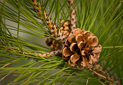
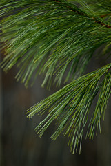
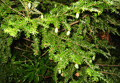

TREE IDENTIFICATION CLUES FOR BUFFALO PARK 


   Evergreen trees have needles and cones. They keep
     their green color all year.

    red pine needles        white pine needles


     Look at the needles to see if they are in a group of 2 or 3
     (Red Pine)


     Look at the needles to see if they are in a cluster of 5
     (Eastern White Pine)


     Look at the needles to see if they are  short, flat and white
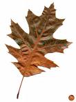
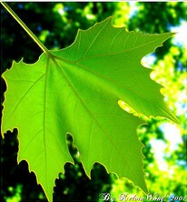
     ribbed underneath (Hemlock)

hemlock branches


     Broadleaf trees have leaves and fruits or flowers.
     They drop their leaves in the fall.

    
 Oak Leaf   maple leaf 

     Look at the leaf.  Does it have 5-8 lobes?
     Is the leaf 5-9 inches long? Is the leaf
     smooth underneath? If yes to all, it could be
     a Red Oak.

     Look at the leaves. Are they opposite one another? Do they
     have 5 lobes with toothed edges? If yes, it could be a
     Sugar Maple leaf.


            Archived Newsletters


Ef