A Special Place to Visit in Tilton
The town of Tilton has many special places –
natural, historic, architectural, and retail.
This Tilton Conservation
Newsletter offers a glimpse into one of those special places –
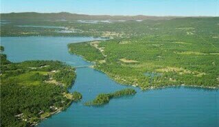
Lake Winnisquam
Lake Winnisquam is the fourth largest lake
in New Hampshire at over 4,000 acres.
It feeds from the larger Lake Winnipesaukee and empties into the
Winnipesaukee River which then flows into the Merrimack River.
The lake is 10.5 miles long and 1.5 miles wide with a maximum depth of
170 feet.
Five towns share the lake which was once the home of the Abenaqui
people-
Tilton, Belmont, Laconia, Sanbornton, and Meredith.
Today the lake draws locals and visitors because of its beauty, boating,
and fishing.
 Tilton Awarded EPA
Grant to clean up Ernie's
Tilton Awarded EPA
Grant to clean up Ernie's
The Environmental Protection Agency
has
selected Tilton for a Brownfields Grant
of $200,000 to clean up the property known as Ernie's Garage on 180 East
Main Street.
The grant will be used to demolish the crumbling garage and to remove
contaminated
soil from the almost one acre property. Once the clean-up is completed,
the area
next to the Winnipesaukee River will become a green space as well as the
home of the
Missing Link Bridge which will connect the parts of the Winnipesaukee
River Trail from
Trestle View Park in Franklin to Route 140 in Tilton completing the
five-mile trail.
The lot will also be a place where people can launch canoes and kayaks.
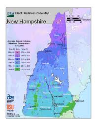
New USDA Plant Hardiness Zone Map
Gardeners should be aware of the new
2012 USDA Plant Hardiness Zone Map which has
been developed using temperature data from a longer and more recent
time period.
The map is designed for gardeners/growers to determine which plants
are most likely
to thrive at a particular location. Zones in NH range from 3b to 6a
which means that a zone
could have winter temperatures as low as -35 F to -5F. The USDA maps
are online at
http://planthardiness.ars.usda.gov/PHZMWeb/# and will even let
you type your zip code so
that you can determine the hardiness zone for your area.